Erin Arrives! (Or What's Left Of Her)

It began raining Saturday afternoon, and as it has been so blasted hot recently I ran out to sit on the front porch with my wife and enjoy the respite. We noticed that the air smelled different than it usually smells during a summer storm. My wife, born and raised in Panama, recognized it immediately: tropical moisture. Technically speaking, I suppose most of the moisture that we get in Oklahoma during the spring and summer is "tropical," given that it streams up from the Gulf of Mexico, but this was different some how. I noticed that the rain seemed to come in waves, or bands. It would rain heavily for awhile, then subside, then increase again. It made for a pleasant afternoon, but I didn't think much of it. I assumed that it would all blow through in a few hours.
An hour and forty minutes ago, at 3:00 a.m., I woke to the sound of rain pounding on the roof and thunder rumbling. I came into my office and turned on the weather radio, only to be hit with a tornado warning for an area about ten miles west of where I live. That got my attention, so I turned on the television and tuned to a local news outlet. The radar image above shows a very unique weather phenomenon, at least for this part of the country. The low pressure area that formed the core of tropical storm Erin, which came ashore on the Texas gulf coast and moved northward across the state over the past two days, has apparently re-intensified as it moved into western and central Oklahoma. Note that you can see a very clearly defined "eye" at the center of a very heavy band of rain. It's not a tropical storm at this point, of course, not even precisely a tropical depression. But it is certainly impressive.
The rainfall amounts are amazing. Some areas have had nearly eight inches in just over an hour. Journalists are out and about even as I type this, and they are reporting flooding even in areas that typically do not flood. In the areas where flooding is more common, eight to twelve inches of running water is shutting down streets and highways. Two main factors are contributing to what may become a rather dangerous situation here in central Oklahoma, particularly the north central region. As the low pressure system rotates counter clockwise, bands of heavy precipitation spin off and move west to east across the same areas over and over. Also, the main low pressure system, which is causing the whole mess, is moving very slowly, meaning that those areas in the northwest quadrant of the low are stuck in an absolute deluge. If this thing slows down, or, God-forbid, stalls, this could turn into a real disaster. As it stands right now, the southern edge of this low is going to rotate right across Oklahoma City as it moves slowly west to east. There are reports of 50 mph winds and, yes, more rain.
As soon as the sun comes up I'll run out and take a few pictures, and update the situation. A strange weather situation, to be sure. Hopefully not a deadly one as well.
UPDATE: Shot this video at the creek near my house, flooding:
...and this, not far from my home: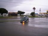
UPDATE: City of Kingfisher, Oklahoma, flooded. The water is still rising.


No comments:
Post a Comment